
Ariel Lopez offers a brief reflection on how colonial-era border agreements continue to shape everyday life and mobility on Sebatik Island, situated between Indonesia and Malaysia.
For four days early last June, project member Ariel Lopez, visited Sebatik island divided between the Indonesian province of North Kalimantan and the Malaysian state of Sabah. In this blog, he reflects on how colonial-era treaties continue to shape not only the policies of present-day Southeast Asian states but also of the lives of people along the border zone.¹
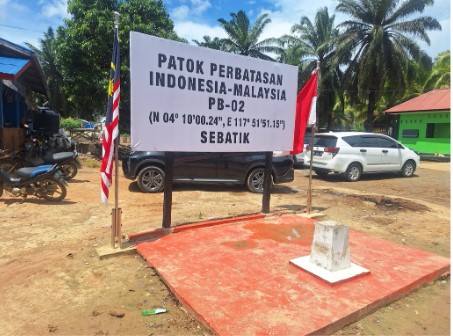
Border marker between Malaysia and Indonesia in inland Sebatik island (Photo taken by A Lopez)
Pak Arief,² a local government official of the kabupaten (regency) that covers the Indonesian part of the island of Sebatik relates that of his five siblings, two hold Malaysian citizenship while the rest are Indonesians. Families whose members hold varying citizenship are common this area, according to Pak Arief. For states like Indonesia and Malaysia where dual citizenship is virtually impossible, the choice of passport could have life-defining consequences to the trajectories of lives of individuals and families. While the general pattern seem to have been Indonesians, mostly Bugis, working and migrating to the bustling Malaysian city of Tawau (Sabah), there are also Filipinos (most of whom are Sama-Bajau) choosing to stay and inter-marrying in the Indonesian-part, with the local Tidung people.
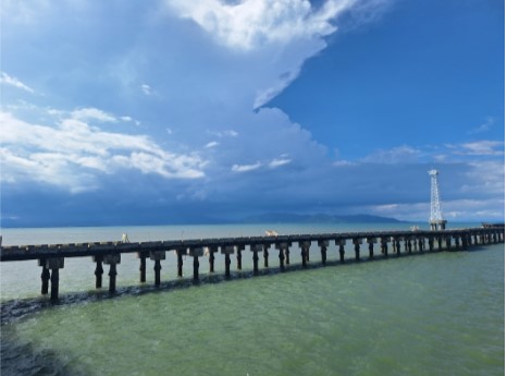
Photo of the recently constructed dock on the Indonesian side with the Malaysian city of Tawau in the background (Photo taken by A Lopez)
In recent years, the Indonesian central government has strengthened its presence in the border region by building a modern dock for large ships and an international passenger terminal with an imposing statue of Sukarno, Indonesia´s founding father, in its expansive yard. These steps towards greater governmentality, however, belies the continuing mobility of goods and people that remain invisible to the central state. The Indonesian state´s interests in strengthening its borders stem partly from the continuing disagreements with Malaysia on maritime delineation. Celebes Sea is particularly contentious as it contains rich deposits of natural gas especially in the nearby Ambalat block. Early this year, Sebatik island came to national attention in both Indonesia and Malaysia after the pronouncement from then Indonesian Presidential Chief of Staff Muhammad Qodari that Indonesia supposedly gained 127.3 hectares of land in Sebatik island from Malaysia.³
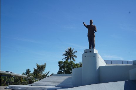
Statue of Sukarno, Indonesia´s founding President, built outside the international passenger terminal of Sebatik (Photo taken by Abdika)
The unresolved borders of recent years stemmed mainly from the dissonance between actual, on-the-ground border-markings and the 1891 border convention between The Netherlands and Great Britain. The 1891 agreement between the colonial powers, despite its inherent limitations, had long served as a reference document for later border disputes between the inheritor states of Indonesia and Malaysia. In the second half of the nineteenth century, Dutch and British colonial authorities increasingly expanded and asserted the territorial extent of their respective jurisdictions on Borneo. The 1877 and 1878 treaty of concessions signed by the sultans of Brunei and Sulu, respectively, with Baron von Overbeck, and which covered much of north and northeast Borneo incited the modern territorialization of the region. The Dutch perceived the concession as in in contravention of the spirit of the Anglo-Dutch Treaty of 1824. In retaliation, the Dutch flag was raised in Batu Tinagat (near present-day Tawau) and by 1883, a Dutch controleur was stationed in Tawau itself.⁴ Several 19th century Dutch maps placed the northern border inconsistently in various latitudes and without consideration of the actual terrain. The Algemeene Atlas van Nederlandsch Indië (1853-62) for instance, draws a clean line between areas under "Dutch possession" and the "gebied van Soeloe of Solokh" or the region of Sulu, later to become British North Borneo. In 1912, a joint Dutch-British commission surveyed the interior of Borneo to take into account the terrain, mainly rivers and mountains, as references for border-making.⁵ Notwithstanding these colonial and similar postcolonial border negotiations, there remains an unresolved OBP (Outstanding Boundary Problem), namely between the Indonesian province of West Kalimantan and the Malaysian state of Sarawak.
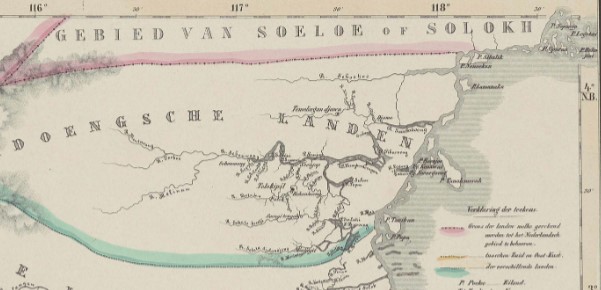
From: Melvill van Carnbée and Versteeg, Algemeene Atlas van Nederlandsch Indië, 1853-62.
The arbitrariness of border-making is perhaps nowhere as glaring as in the "Rumah Dua Negara" (house of two states) (see photo below) where the living room fell into Indonesia while the dining area and kitchen belonged to Malaysia. The house has become an icon and indeed a museum to show how communities, families and actual houses are divided by imaginary borders. Alas, the house has technically lost its de jure "dua negara" status when the border was recently moved to conform to the 1891 border convention.
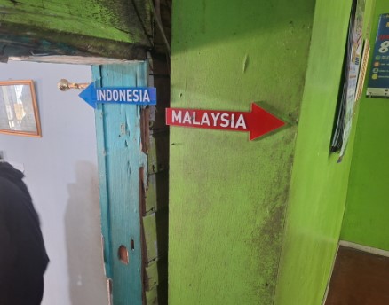
The "rumah dua negara"
Sources:
-
The author acknowledges Dr Lina Puryanti of Airlangga University, Surabaya, Indonesia and the Airlangga Institute for Indian Ocean Crossroads for the opportunity to visit the research site.
-
Pseudonym
-
https://www.thestar.com.my/news/nation/2026/04/16/hajiji-denies-sebatik-land-handover. Accessed 29 Jul 2026.
-
Irwin, Graham. Nineteenth-Century Borneo: A Study in Diplomatic Rivalry. ’s-Gravenhage: Martinus Nijhoff, 1955, p. 206.
-
Ibid.
Text by: Ariel Lopez